transit

Episode 14: parking, land use and transit with Rachel Weinberger

Parking is a very important factor in urban design and transport mode choice, yet is frequently overlooked as cities consider it part of zoning codes rather than transportation infrastructure. Sustainable transportation consultant Rachel Weinberger joins me to explain the connections between parking, transit and the urban environment. The costs of driving are not only heavily subsidized by all levels of government but also bundled into the costs of goods and services in the public and private sectors. As a result, the provision of free or cheap parking (and the perceived endless need for it) promotes driving and makes it more difficult to walk or use other transport modes. We also talk about her work on the original PlaNYC and other transportation politics and trends.

Find out more about Rachel Weinberger by reading her research papers and and in coverage on Streetsblog.

Please send questions, comments and suggestions for future topics or guests to feedback@criticaltransit.com.

No Turn on Red

One of the most dangerous laws in the United States is the provision permitting drivers to turn right on a red light. It was one of a few terrible 1970s policy changes, along with raising highway speed limits from 55 to 65 mph, which pretended to reduce gasoline use and emissions during the US gasoline shortage. Environmental awareness began increasing at that time but even today most people don't recognize that anything you do to make driving easier and faster actually encourages more driving. The theory of induced traffic demand shows that adding motor vehicle capacity or improving traffic flow is always going to increase traffic demand and congestion. Research by the Federal Highway Safety Administration confirms my experience:

While the law requires motorists to come to a full stop and yield to cross street traffic and pedestrians prior to turning right on red, many motorists do not fully comply with the regulations. Motorists are so intent on looking for traffic approaching on their left that they may not be alert to pedestrians on their right. In addition motorists usually pull up into the crosswalk to wait for a gap in traffic, blocking pedestrian crossing movements. In some instances, motorists simply do not come to a full stop. ...

Prohibiting right turns on red will significantly improve pedestrian safety.

A common problem is that no turn on red signs are typically located on the far side location where they are less visible. Traffic signs and signals should always be located at the near side of the intersection, prior to the crosswalk, so that drivers have to stop before the crosswalk in order to see when the signal changes to green. If an advance stop line is used the signals should be placed so that motorists stop there.

Focus on service quality, not cost

In today's political climate of artificially tight budgets, it's far too easy to fixate on costs and nothing else. Comparisons among light rail systems in different cities (or even in the same city) are almost always rendered invalid by the wide variations in service outcomes and specific construction requirements. Costs are impacted by many things beyond distance and vehicle type, although these are often ignored by those trying to score cheap political points. The planned service characteristics and facility layouts have to work with the existing land use, streetscape and utilities. If you want to build and operate high quality transit service, you need to invest a lot in infrastructure, so the capital construction cost will be higher than the cost of low quality transit without new infrastructure. That decision should be based on what kind of transit is necessary to meet the current and future demand for transportation, is very specific to the particular site. Remember also that higher quality transit reduces ongoing operating costs. A fast subway yields great savings over a slow light-rail line that may be cheaper to build, just as implementing so-called "bus rapid transit" wastes far more operating money than doing it right.

Stephen Rees says it best on his blog when talking about the Vancouver subway proposal:

But just looking at costs – and trying to minimize them – is not a good way to plan a transit system. You have to look at the benefits too – and there are always judgements that are going to be made. ... Look at the Canada Line. It was built down to a price, not up to a standard. It is therefore less safe than it could be. There are no platform edge doors, which are standard for new automatic train operated subways elsewhere. It is inconvenient with only one entrance for each station, forcing passengers into crossing the road on the surface which is also a safety concern. It is not going to be big enough if Vancouver actually achieves its 2040 goals: the platforms in the stations just cannot accommodate much longer trains.

Focusing on the cost of capital construction means devaluing the service, providing lower quality transit than should be provided, and spending more money in the long run than is necessary.

Episode 13: News, politics, upgrading busy routes, transport costs and mode choice

A summary of news items turns into a discussion of how cities can use rail to increase capacity while reducing operating costs on overcrowded high-frequency bus routes. Too many people want rail for the wrong reasons, but the most convincing argument for rail is when you can't run enough buses to deal with demand. At the same time, rail is not inherently better than buses, but most people think that is the case because we usually provide high quality rail service and low quality bus service. Hurricane Damage Cost New York City MTA $5 Billion; Nova Scotia intercity bus regulation change increased operator flexibility; transit users save $9,798 annually but only if you don't already own a car; parking makes cities less walkable and transit friendly; cities make people more liberal and open-minded; Vancouver to upgrade 99 B-Line bus to subway (as it should); Minneapolis has also been upgrading busy bus lines to light rail (construction updates); Ottawa is upgrading their model BRT system to light rail. Pittsburgh has three excellent busways.  Read more about bus rapid transit in other places like Bogota and Curitiba. And you can follow Toronto's mayoral saga or the more interesting transit expansion news and the new US House T&I Committee chairman.

Follow the blog at CriticalTransit.com; also leave a message, and subscribe to the podcast feed. Send email to feedback@criticaltransit.com.


Vancouver wants (and needs) a subway on Broadway

Last week the city of Vancouver proposed building a subway line to replace the 99 B-Line bus. This TransLink route carries over 160,000 people per day, making it by far the busiest bus route in North America (by comparison, New York's busiest bus route, the M15, carries 55,000 daily passengers).  It is a perfect case study of upgrading a successful transit line to a higher capacity technology, for the situations where you just can't run enough buses to keep up with demand. Going back to an earlier post on vehicle selection, we see that rail vehicles hold more people than buses.

Transit Bus (40 feet) 35 seats, up to 65 total ("crush load")
Articulated Bus (60 feet) 57 seats, up to 85 total ("crush load")
Light Rail (70-100 feet) 100 per car, up to 4 cars
Subway 150-200 per car, up to 10 cars

Experience with bus bunching shows us that things start to break down when you're running service every 5 minutes or less. It's very difficult to manage the service in a way that keeps buses spaced out, and as you add more buses they just become more crowded and the bunching gets worse. This can happen with rail as well, worsened by the inability for vehicles to pass each other. (On the trunk portion of Boston's Green Line and New York's subway, for example, every 10-second delay cascades down the line.)

That's when you know it's time to increase capacity. You can run long high-capacity trains with one operator. Surface light rail is usually the way to go, but because ridership grows with a jump in the quality of service (and the 99 B-Line ridership is already so high), Vancouver is right to build a subway. Hopefully they can convince the province and federal government to help pay for it.

Why most Bus Rapid Transit isn't usually Rapid

Following the rollout of Seattle's so-called RapidRide BRT system has been discouraging. The point of Bus Rapid Transit is to make buses fast and reliable, but unfortunately almost all attempts at BRT in North America have been a complete failure. This pretend BRT may help politicians and transportation departments say they've done something while not having to do very much at all. Human Transit explains why in an excellent post this week on the opportunities and dangers of incomplete bus rapid transit:

One of Bus Rapid Transit's great virtues is that unlike rail, you don't have to build a complete, continuous piece of infrastructure if you really only need segments of one. ... A BRT facility that got transit through the chokepoints reliably probably wouldn't need an exclusive lane in the free-flowing segments, because traffic in those segments would continue to be metered by the chokepoints and thus remain uncongested. ...

Unfortunately, Bus Rapid Transit can also be implemented in exactly the opposite way.  Severely congested chokepoints are generally expensive places to design transit priority for, especially if you're unwilling to simply take a lane for transit.  So we often see BRT projects that are missing where they are most needed.  The Boston Silver Line 4-5, like the Los Angeles Silver Line, can get stuck in traffic downtown.  New York's supposed BRT is so compromised that many refused to call it BRT anymore.  Even the world-class Auckland North Shore Busway disappears as it approaches the Harbour Bridge.

The proliferation of so-called BRT is a direct result of car-centric thinking. To most city planners and politicians, car throughput is most important, so "taking a lane away" from cars for transit is something they won't do. As a result, buses only get priority where they don't really need it. Most transit agencies don't control the streets, so they take what they can get and try to make gains from other things like stop consolidation and off-board fare payment. Those should be done for all bus routes though, while BRT should have a dedicated right of way with priority at any conflict points and long distances between stops.

Buses are great tools which can do wonderful things, but the reality that they are never allowed to do those things causes a lot of well meaning transit advocates to figure BRT is hopeless and instead advocate for rail. Buses can be just as effective as rail if we give them the kind of priority and respect that is automatically assumed to be a given for rail lines. (This is why users of Boston's Silver Line continue to demand rail service. It's not that buses can't handle 15,000 daily riders or are somehow superior; it's just that they know that the city wouldn't make trains sit in traffic in the downtown area as buses are always forced to do.)

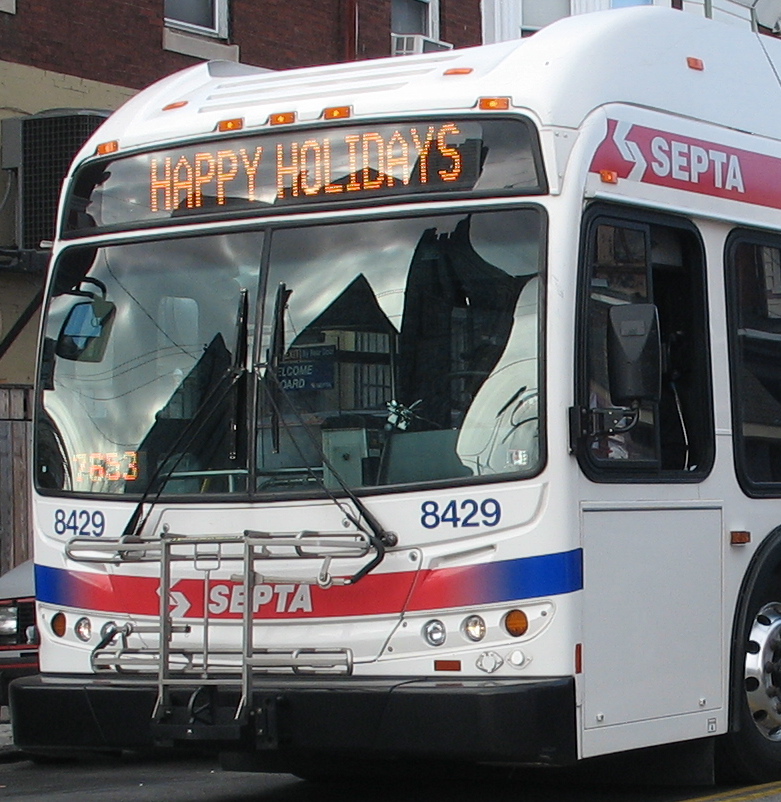
Destination signs are for ... destinations only!

There are three components involved in operating a good transit service: (1) design, (2) implementation, and (3) communication. That third component is often undervalued; in order to make the service useful you have to communicate how it is useful. The destination sign is an important part of this communication.  It conveys crucial information -- " ## TO (place) VIA (street)" -- and should do so very efficiently so that waiting passengers can quickly decide whether to board that vehicle. Whenever possible I suggest limiting the information to two lines with only the most critical information and keeping the route number on both screens. Sometimes you can fit two lines on one screen, as is common in Philadelphia and San Francisco, two cities with a good grid system. An honorable mention goes to Boston for their generally excellent job of this despite operating hundreds of bus routes that couldn't possibly run in long straight lines.

Adding extra information can complicate vehicle identification as it distracts from the most critical information. Just because the sign is capable of having five screens doesn't mean it should.  Save that second or third screen for things like "snow route" or some other important "service alert", or better yet, make a color-coded cardboard sign to stick in the lower curbside corner of the front window if you need to display more info.  But please, for the love of buses ... the destination sign is for route descriptions only!  Not this:


Does that line tell you if this is your bus?

Not to pick on SEPTA as it's far from the only one.  And whoever programmed this useless information was probably trying to be all nice and cheery, but ... stop it!

All about transit in Boston

Boston is a great place to visit (and live) and offers lots of great lessons on transit service design and operation. It has one of the most diverse transit fleets in North America -- heavy rail (subway/metro), light rail (trolley/streetcar/tram), local and express buses (diesel/CNG/hybrid), electric trolley buses (trackless trolleys), regional commuter rail and a handful of commuter ferry routes in Boston Harbor.  The Massachusetts Bay Transportation Authority (MBTA), known locally as "the T", provides service throughout the region and operates all of these modes. You can read all about the MBTA on Wikipedia and the transit history and vehicle roster page maintained by local transit fan Jonathan Belcher. This week's super long show explores only a fraction of the system, including the Green Line light rail/trolley network, Blue Line heavy rail line, Silver Line bus rapid transit (BRT) lines, and the bus network in Harvard Square.

Please send in questions or comments on anything you hear to feedback@criticaltransit.com or comment on this page.

Street grid + transit grid + information = simple and useful network

It's so much easier to get to know a city when it is easy to navigate. The core of Philadelphia is based on a street grid system that makes it relatively easy to find your way while walking. The design of the transit system builds on the grid by operating its routes in a grid, making it easy to find your way by bus. Route information is clearly displayed on destination signs. However, SEPTA could greatly improve the understanding of its grid-oriented route network by numbering routes according to some logical system. For example, odd routes could be north-south, with numbers increasing as you move westward, and any routes not conforming to the grid system could be given a letter or some number above 100.  Some buses here actually do use letters but not for any reason that employees could tell me.

A map goes a long way. While SEPTA publishes a system map, it's not posted anywhere in the system -- not even at the busy Frankford Transportation Center where over 20 bus routes meet at the northern end of the Market Frankford heavy rail line. Luckily I had brought along the map I purchased last time from the SEPTA transit museum store so I could plan some adventures (and just get around). Sadly the map makes an error that is common among transit maps: clearly displaying the handful of rail lines in unique color, thickness and line type, while making all 100+ bus routes appear the same way. When it's hard for a transit fan to figure out, how are others expected to figure it out?

I believe that many more trips would be taken by bus if bus services were easier to understand and were afforded the same traffic priority and station amenities that rail usually gets by default. In the end, most people care primarily about getting from A to B quickly and efficiently.

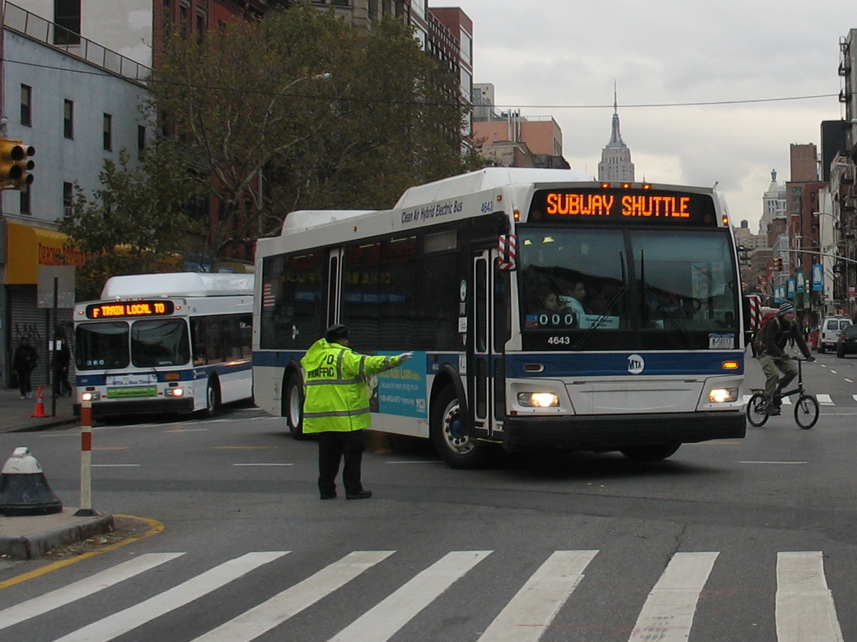
Hurricane Recovery Special with Epic Transit Journey

SubwayShuttle_Manhattan.jpg

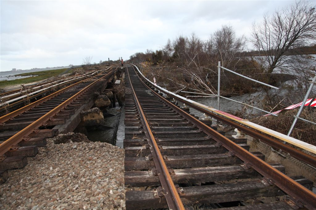
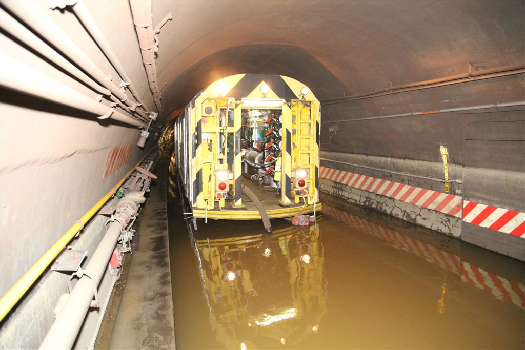
Enjoy this special, extra-long episode on the damage from Hurricane Sandy and the struggle to rebuild devastated communities and submerged transit networks. We have shuttered rail lines, debris and trash all over the streets, massive flooding in stations, hundreds of shuttle buses, missing rail cars, huge neighborhoods in a now-snowy region with no heat or electricity. ... More people are using bicycles and hopefully some will make it their preferred transport mode. This episode features bits of live audio from Boston during the hurricane and from my epic transit journey from Boston to New York via a combination of local bus services when intercity carriers were not running.

Next week is a discussion about bicycling in Toronto with Yvonne Bambrick. Later this month, the rest of my audio from riding the MBTA, walking and biking in Boston.

Great photos of the damage and amazing recovery efforts courtesy of MTA Photos on flickr: