Expanding and Replicating the Cape Flyer

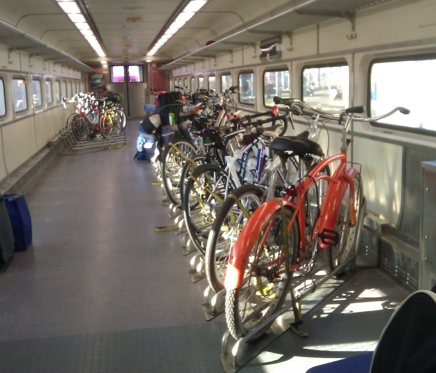
Last weekend I finally took my bike on the Cape Flyer train to Cape Cod as part of a camping trip, and it was fantastic.

Now in its third year, the Cape Flyer has made getting to the popular vacation peninsula possible for car-free people (it's wasn't impossible; just not usually worth the hassle) and reasonable for those who aren't interested in the 12-mile traffic backups at the bridge. As a result it is very popular yet could benefit from improvements and potentially be a model for similar services elsewhere.

Where it excels

First off, it exists. The only other car-free options are a bus that sits in the same traffic as cars and a very expensive ferry. I won't even suggest biking because those bridges are possibly the scariest place I've ever tried to bike. Many people in Boston have never been to the Cape because it's just a pain to get there.

Useful connections are available in Buzzards Bay and Hyannis to island ferries and local buses, so you can actually go beyond the station, removing a major barrier to vacationing by transit. Because it's all coordinated, it actually works out and you won't miss the train because a shuttle is stuck in traffic.

The train is reasonably convenient with stops at South Station, Braintree, Brockton and a parking lot in Middleborough. The schedule, while very limited, provides for a Friday evening train and then an 8am outbound train Sat/Sun morning and 6:40pm return train Sat/Sun, which works for a weekend getaway.

An entire coach is dedicated for bikes and there's plenty of room for whatever junk you "need" on your vacation. There's no way I would try fitting my bike and all my camping gear under a bus and risk not being able to get back.
 
The price is reasonable. There's a cafe car and decent wifi.

Opportunities for Improvement

Frequency: As a weekend vacation oriented service, the limited schedule necessitates careful planning and leaves no room for error (miss the return train and you may be out of luck). There's also no chance of stopping in Buzzards Bay for a few hours to walk or bike the canal path before continuing over the bridge.

The service could be expanded by offering limited weekday service (one round-trip each in the morning and evening) and adding trips on the weekends to permit flexibility in travel plans and create a new option for Cape Cod residents to visit Boston.

Additional stations would offer more options to those traveling by bike and provide more convenient bus and shuttle connections. A station is currently being built under the Bourne Bridge on the south (Cape) side of the canal, which opens up more options and keeps both bikes and shuttle buses from having to use the dangerous bridge. Sandwich and West Barnstable have old train station which could be reactivated.

Travel Time: Once the train reaches the cape it operates with speed restrictions because the track south of the canal is designed for slower freight trains. The 2-hour 20-minute trip could be significantly faster with some track upgrades.

Local Transit: The Cape Flyer ends in Hyannis and cannot easily be extended further east as no rail line exists. While there are useful bus connections at the Hyannis Transportation Center, most are slow local, hourly routes designed more for local residents' needs like work and food shopping than those of visitors. Investments in more frequent connecting local transit service and new express/shuttle service to points east and west would make traveling beyond Hyannis more feasible and give travelers more options. Either way, more information about these transit options should be more readily available on the train and in places riders are likely to be at other times (before planning their trip) like South Station or, uh, the internet.

Opportunities for similar services

The Cape Flyer has been a profitable venture so far, aside from one-time capital expenses (new stations, track upgrades, etc.) and could be a model for other experiments in regional rail service. The Berkshires and White Mountains come to mind. It's also a good time to rethinking our "commuter" rail system and how the schedules could better serve all types of regional travel (increased frequency, better stations, shuttles, coordination with local transit, and more).

CT Fastrak opens. More busways, please.

It's been probably over a hundred times I've passed through Hartford, but always passing through, making a bus connection for New York, Boston or Worcester, at Union Station. The station itself is nice enough, a major intercity bus hub and Amtrak station, adjacent to downtown with the large Bushnell Park almost directly across the street. Hartford is the state capital of Connecticut with a resident population of about 125,000 and, like most old cities, is experiencing significant residential and commercial growth.

Yet somehow despite dozens of missed bus connections -- less frequent these days as Peter Pan Bus operations have significantly improved over the past decade, and also because I tend to avoid traveling on holiday weekends -- I never have managed to take time to explore Hartford.

This weekend I was also passing through, en route to northeastern Pennsylvania to visit family. But this time I got to ride a piece of the new New Britain - Hartford Busway, just opened alongside the Amtrak inland route and branded as CT Fastrak.

It comes with well-spaced stations, passing lanes to accommodate the variety of local and express routes, and is mostly grade separated; travel time for the entire 12 miles including all stops is just 24 minutes. It is taking some time for people to adjust to the route changes but so far CT Fastrak seems to be working well and is a model for other cities. The mayor of East Hartford took a ride and is already advocating for the busway to be extended through that city and into Manchester.

Much effort has been spent on launching "bus rapid transit" lines but typically what we see is not real BRT -- dedicated space for buses with widely spaced stations, level boarding, off-board fare payment and frequent service -- but usually something marginally better than existing local bus service as we know it. See Boston's Silver Line, New York's Select Bus Service, Washington's MetroRapid and many others. Compared to branding and focusing on a single route, building a running way facility that multiple services can use provides a major benefit.

Pittsburgh is well known in the transit world for building its first busway 30 years ago and two more since then, though the stations and could use a major upgrade and the buses need priority downtown. Just about every city has unused rail corridors or low-volume highways that are waiting for a more productive use, yet very few have built serious priority facilities for buses, which are of course the most efficient way of moving large numbers of people.

Some have criticized CT Fastrak, mainly for exceeding its budget. But what recent transportation project has not experienced cost overruns? With long project timelines, rising construction costs, problematic federal cost-effectiveness metrics and the widely used practice of automatically choosing the lowest contract bidder, transit projects are all but guaranteed to exceed their budget. Cost alone is not a good reason to oppose a particular project, arbitrarily deciding that X is  "too much money"? What is X? $40? $40 million? $2 billion? Why? Who decides this? And isn't the point of a government to pool resources so we can provide services that would otherwise be impossible?

More busways, please.

By the way, the cheapest way to create a busway is to mark it off with cones, especially if you're just testing it out.

Welcome to the new Critical Transit

If you found this page, you're in the right place.

I am in the final stages of moving the site to a new web host so it's faster, more reliable and easier to use. This is exciting because I can share more content and we can interact more. Stay tuned! For now check out my local transit advocacy work via Transit Matters and dig into the podcast archive (only old episodes at that link).

IMPORTANT NOTE: The site address (criticaltransit.com) will remain the same but the RSS feeds for the blog and podcast will change. Follow the new feed for the blog and podcast:

As always, drop me a line is anything looks weird or if you have questions, comments or suggestions.

I'm back ... in Boston ... and Critical Transit continues!

Critical Transit is back after an unplanned break, and we're moving in a new (local) direction as part of a push for better transit in Boston. Learn all about the future of Critical Transit in this mini episode. Subscribe to the blog and podcast (iTunes), follow my thoughts on @criticaltransit on Twitter, like the Facebook page, and stay in tough with your reactions, discoveries and suggestions for topics or guests. Email feedback-at-criticaltransit.com or use the contact form.

Transit Tip 14: Beware of useless bike lanes

There's a tendency among bike advocates to champion the delineation of a "bike space" even without any actual space being created. You know, "if there's room for a bike lane" without changing anything else on the street. At best you get no benefit, and at worst you're given a "safe space" that isn't safe at all. This bike lane is almost entirely in the door zone, which is why these users are staying to the far left. But cars will pass too closely (up against the line) so they really should be riding outside the bike lane for safety, but then motorists become arrogant and hostile as they think you're being a jerk.

JP-CentreSt-nreionline-com

That's when cars are parked flush against the curb. Even in the summer they often intrude into the bike lane. But in the winter the lane is completely taken away for car parking. Bike lanes in Boston are only open 1/3 of the year. And it's always the bikers and pedestrians who lose out; car drivers get plowed streets and the same ability to park their personal property: who cares if anyone else has trouble getting around?

You can see the city's priorities. They claim to be a "world-class bicycling city" where "the car is no longer king" but what this street design really does is appease some bicycle advocates while maintaining a car dominant streetscape. Fail.

This major business district is also a major transportation corridor. The 39 bus seen here is one of the highest ridership MBTA lines, yet all winter it struggles to pass arrogantly parked cars, often waiting for opposing traffic before it can cross the centerline. Buses often can't pass each other.

In a fairer city, cars that park outside the designated space would be ticketed and towed immediately. Better yet, restrict parking in certain spaces that can be used to store the snow that the city should be removing from sidewalks.

Snow Plowing by Bike

Yes, for those of you who pointed out that properly clearing snow from sidewalks would require burning more fossil fuels ... I present the bike snow plow:

You could add a salt spreader to the back if you really want to excel.

My second response is that even if you did use motorized plows, there would be a measurable decrease in the number of people who drive because streets and transit stops are not accessible to pedestrians.

Transit Tip 13: Make a Snow Plan

It's been a day of heavy snow here in Philadelphia. While viewing the city from its trains and buses was quite pleasant, a snow storm presents significant challenges for transit operators. Depending on the timing of the storm, either buses and streetcars will be stuck in heavy traffic or they will be empty and running on time as nobody goes anywhere. SEPTA bus 44 in Ardmore, PA

It makes sense to reduce scheduled service on most lines to match reduced ridership and make more buses (and drivers) available to respond to special needs that will arise - Some lines will require snow routes that add significant time and require an extra bus. Other needs include stalled buses, extra trips, rail replacement shuttles, evacuations and more.

Vehicles take a lot of abuse during a blizzard and that means many may be out of service the following day. Don't run the risk of having to run 70 percent of normal service on several subsequent regular days because you couldn't be bothered making a snow plan.

Plan ahead and communicate. Everything in a snow plan, from route detours to service reductions to plowing busways, can be planned ahead of time and strategically implemented early.  That means employee shifts can be different, supervisors will know what to do and what scenarios to watch for, and customers will know where to find a snow route -- but only if the information is made available in advance, such as in timetables and maps.

Meanwhile, we can look to Hampton Roads Transit for a completely inexcusable three-day bus shutdown as the agency is apparently afraid that someone will slip and fall while boarding a bus.

Transit Tip 12: Keep pedestrian and bike paths free of obstructions.

There's usually a buffer space between the sidewalk and the street where signs, utility poles, mail boxes and other things can go. Bus stop signs, for example, must be placed 1-2 feet back from the curb so the bus mirrors don't hit them.  But if you get rid of the buffer area to add parking or maximize the driving lane width, don't encroach on the already narrow path for parking meters, construction signs or anything else that doesn't belong there. IMAG4720

Also, to all the highway engineers out there, if you put any objects on the sidewalk, remember that the sidewalk has been narrowed. It's not a 5-foot (1.5m) sidewalk if 2 feet are taken up by poles and signs.

This is a 2-foot (0.6m) clear width, less than the minimum required, even while the driving width is at least 30 feet (9m).

Check out Perils for Pedestrians has a wealth great info on walking paths.